A) 1 and 2
B) 2 and 3
C) 3 and 4
D) 1 and 4
E) None of these are correct.
Correct Answer

verified
Correct Answer
verified
Multiple Choice
This figure shows a new well that will pump out groundwater faster than it can be replaced.What will the water table look like after pumping? 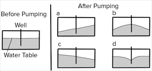
A) A
B) B
C) C
D) D
Correct Answer

verified
Correct Answer
verified
Multiple Choice
Which of the following is occurring in the Snake River Plain of southern Idaho?
A) Water from rivers soaks into the ground,causing the rivers to disappear (be lost) .
B) A large amount of water flows underground.
C) Huge springs result where groundwater flows onto the surface.
D) All of these are occurring.
Correct Answer

verified
Correct Answer
verified
Multiple Choice
Of the following choices,the best indicator of drought is
A) soil-water use.
B) soil-water recharge.
C) height of the saturated zone.
D) deficit.
Correct Answer

verified
Correct Answer
verified
Multiple Choice
How would this stream interact with groundwater? 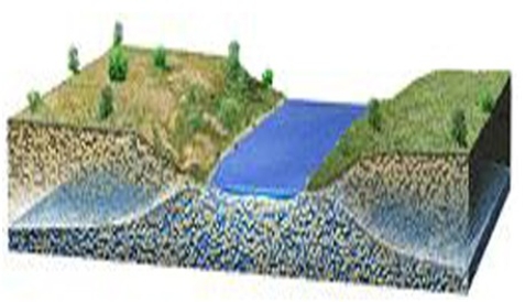
A) Groundwater would flow sideways into the stream,adding water.
B) Groundwater would flow upward,adding water to the stream.
C) The stream would lose water to the groundwater.
D) The groundwater and stream water would not interact.
Correct Answer

verified
Correct Answer
verified
Multiple Choice
Which of the following would be most useful in investigating groundwater contamination?
A) Records of how much material the company may have spilled
B) Records of health problems,like leukemia,of people living in the area
C) A map showing contours of the water table and of contamination levels
D) A geologic map
Correct Answer

verified
Correct Answer
verified
Multiple Choice
This water balance diagram below suggests that 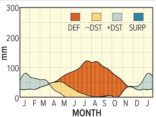
A) the location is in the Southern Hemisphere.
B) winters are snowy.
C) long periods of drought are common.
D) All of these are correct.
Correct Answer

verified
Correct Answer
verified
Multiple Choice
The area shown on this cross section will experience subsidence from groundwater withdrawal.Which of the following statements is likely to be true about the subsidence? 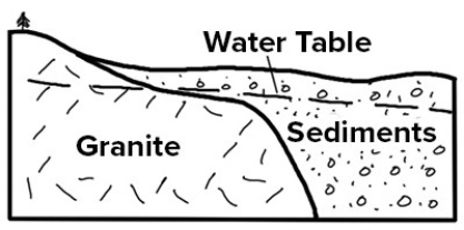
A) The amount of subsidence will be constant across the area.
B) The aquifer will regain its porosity once the water is replaced.
C) The subsidence can be reversed (undone) by pumping in saltwater.
D) None of these are correct.
Correct Answer

verified
Correct Answer
verified
Multiple Choice
Which of the following variables would be used to estimate potential evapotranspiration?
A) Temperature and precipitation
B) Precipitation and evaporation
C) Temperature and latitude
D) Wind speed and latitude
E) Precipitation and humidity
Correct Answer

verified
Correct Answer
verified
Multiple Choice
This map shows contours of the water table and the location of a factory that contaminated the groundwater.Which way will the contamination flow? 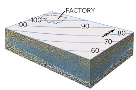
A) Northwest,up the contours
B) Southwest,parallel to the contours
C) Southeast,down the contours
D) No direction because the movement of contamination is independent of groundwater
Correct Answer

verified
Correct Answer
verified
Multiple Choice
Which one of the following statements is true regarding the Earth's supply of fresh water?
A) The largest volume exists in lakes and reservoirs.
B) There is more in the form of water vapor in the atmosphere than there is as liquid groundwater.
C) There is more freshwater in glaciers and ice sheets than exists as groundwater.
D) There is more water in rivers than exists as soil moisture and groundwater.
Correct Answer

verified
Correct Answer
verified
Multiple Choice
How would this stream interact with groundwater? 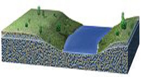
A) Groundwater would flow into the stream,adding water.
B) The stream would lose water as water in the stream flows sideways and up.
C) The groundwater and stream water would not interact.
D) The stream will only contain water if it is raining at that time.
Correct Answer

verified
Correct Answer
verified
Multiple Choice
The water balance diagram below suggests that 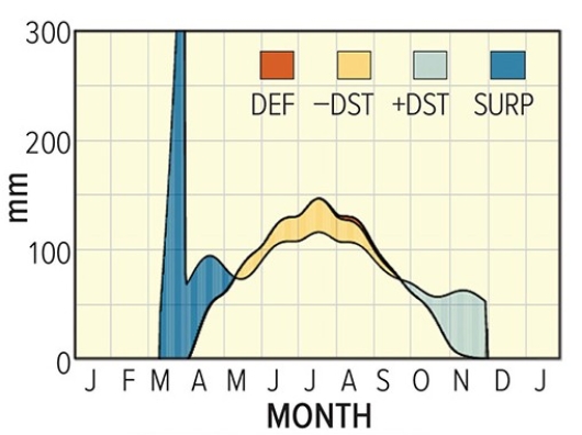
A) summers are very dry.
B) winters are snowy.
C) long periods of drought are common.
D) All of these are correct.
Correct Answer

verified
Correct Answer
verified
Multiple Choice
Which of the following is not a possible source of water contamination?
A) Dry cleaners
B) Farms
C) Rocks that have been mineralized by natural processes but not mined
D) Houses
E) All of these are possible sources of contamination.
Correct Answer

verified
Correct Answer
verified
Multiple Choice
Each number on this figure refers to a location depicting groundwater in a subsurface material that is consistent in character across the entire figure.Of these locations,which one would have groundwater flowing to the left? 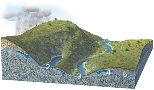
A) 1
B) 2
C) 3
D) 4
E) 5
Correct Answer

verified
Correct Answer
verified
Multiple Choice
Which of the following energy sources drives the hydrologic cycle?
A) Internal heat energy
B) River flow
C) Wind energy
D) Solar energy
E) Gravity
Correct Answer

verified
Correct Answer
verified
Multiple Choice
Of these four lakes,which ones are above the water table? 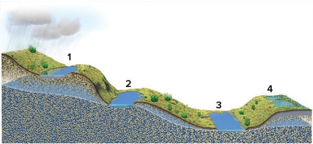
A) 1 and 2
B) 2 and 3
C) 3 and 4
D) 1 and 4
E) None of these are correct.
Correct Answer

verified
Correct Answer
verified
Multiple Choice
The hydrologic cycle refers to
A) seawater that is drawn into mid-ocean ridges,heated,and rises to the surface.
B) water that is heated by magma and rises in hot springs.
C) the rising and falling of tides in a cyclical manner.
D) the way water is used to generate electrical energy.
E) None of these are correct.
Correct Answer

verified
Correct Answer
verified
Multiple Choice
Where on this cross section would water at the surface become groundwater? 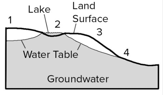
A) 1,2,and 3
B) 1 and 3
C) 2 and 4
D) 2 only
E) 4 only
Correct Answer

verified
Correct Answer
verified
Multiple Choice
The water table in the Investigation was lowest in elevation along the
A) north edge.
B) east edge.
C) south edge.
D) west edge.
Correct Answer

verified
Correct Answer
verified
Showing 41 - 60 of 83
Related Exams